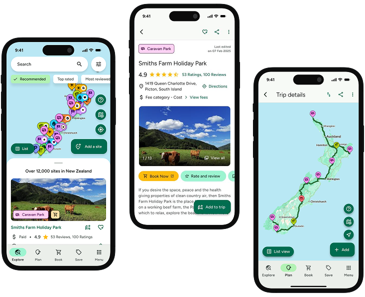
INTRODUCING
BOOKINGS ON WIKICAMPS
Tramline Track
 Point of Interest
Description
The Tramline Track system traverses most of Great Barrier island at its widest point. 8 km one way.
The Tramline Track receives minimal upkeep - for fit trampers only.
From its northeastern beginning on Aotea Road, the track follows the old tramline used by the Kauri Timber Company during the 1920s and 1930s. It is sometimes very steep and was a remarkable engineering feat of its time.
It descends abruptly to Awana Stream and Waterfall before climbing steeply to a plateau and then dropping to Kaitoke Stream. The track crosses several creeks, crossing Forest Road and linking with the Whangaparapara tramline extension.
Shorter option
From the Whangaparapara end, the track progresses over several bridges before joining Forest Road (1hour). The Pack Track is permanently closed.
No dogs.
Find this site and more on WikiCamps
Take the ultimate camping companion on your next trip, with these great features:
![]() Explore more than 60,000 sites across New Zealand with detailed site information at your fingertips
Explore more than 60,000 sites across New Zealand with detailed site information at your fingertips
![]() Stay in the know with exclusive, insightful reviews from fellow travellers
Stay in the know with exclusive, insightful reviews from fellow travellers
![]() Map journeys, plan your route, and gauge your fuel spend with Trip Planner
Map journeys, plan your route, and gauge your fuel spend with Trip Planner
![]() No signal? No worries! Use offline mode to travel anywhere with WikiCamps
No signal? No worries! Use offline mode to travel anywhere with WikiCamps
![]() Add sites to your collections, search with intuitive filters, and so much more...
Add sites to your collections, search with intuitive filters, and so much more...
Get WikiCamps now!
Download WikiCamps from the App Store on your device.

